

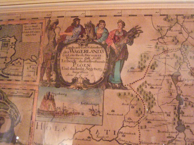
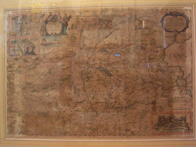
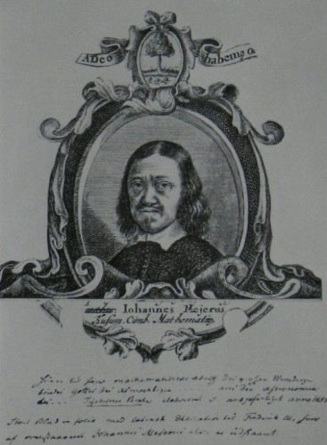
Johannes Mejer (* 1606 in Husum; † 1674) Old map of Holstein anno 1650 (Wagerland)
Price:
On request
Product details
| Product number: | 666 |
| Material: | Engraving |
Product description
Johannes Mejer (* 1606 in Husum; † 1674) was a Schleswig cartographer.
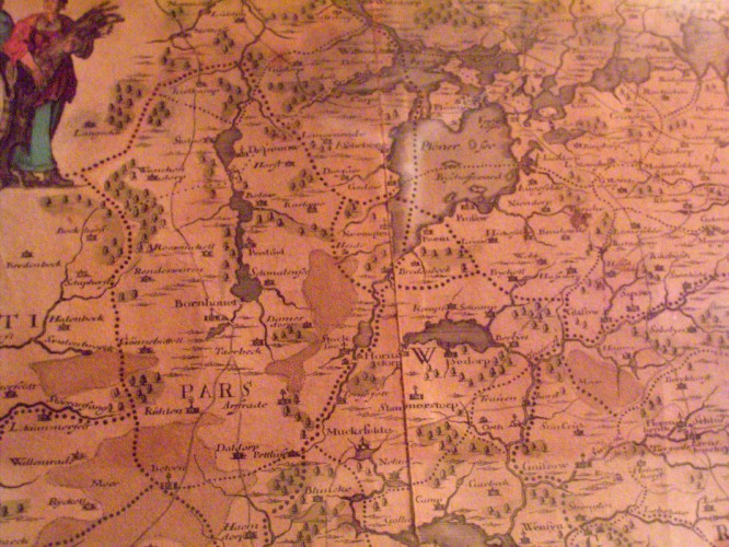
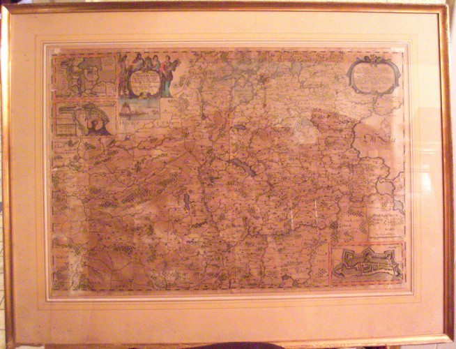
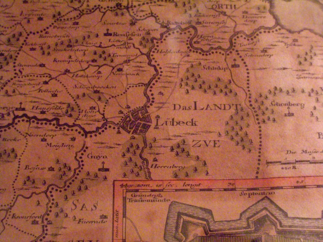
Old map copper engraving of Holstein with Segeberg, Plön, Storman, Lübeck. (Wagerland) Dimensions: 62 x 43 cm without frame in an old Berlin bar (free).
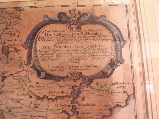
Mejer studied in Copenhagen. At the university he learned the basics of cartography, which had been practiced there since Tycho Brahe. Returning to Husum around 1629, Johannes Mejer worked as a teacher, occasional poet, calendar maker and cartographer. In 1635 and 1636 Mejer worked for Duke Friedrich III. from Schleswig-Gottorf. With his support he went on a study trip to Holland in 1637. On his behalf, Mejer completed an atlas of the Aabenraa office in 1641. He received support from the Apenrade administrator Joachim Danckwerth. Mejer successfully mastered the task of mapping the Schlei with its herring fences. Two copies of the Schlei Atlas with 40 and 43 maps have survived. One is in the Schleswig-Holstein State Archives, the other in the Royal Library in Copenhagen. In 1639, Johannes Mejer drew what is probably the oldest usable map of the island of Helgoland Nova Tabula Helgolandia. In 1647, King Christian IV ordered Johannes Mejer to be appointed royal mathematician. The Danish king commissioned Mejer to first survey the west coast of Schleswig-Holstein. In 1652 Caspar Danckwerth's new description of the two duchies of Schleswig and Holstein was published with 40 maps and city plans by Mejer. The model for Danckwerth's description of the land was the Novus Atlas by Willem Janszoon Blaeu, published in 1645. - Most of Mejer's maps were artistically designed by the brothers Mathias and Nicolaus Petersen and engraved in copper plates by the brothers Andreas and Christian Lorenzen - called Rodtgiesser.
Throughout his life, Mejer felt indebted to the great Danish astronomer Tycho Brahe. He adopted its worldview and had a depiction of it engraved in copper in 1651. Johannes Mejer died in 1674. Mejer's estate is kept in the Royal Library in Copenhagen. Mejer's maps of the duchies of Schleswig and Holstein served as a basis for well-known cartographers and publishers (Janssonius, Visscher, Schenk, Homann, Seutter, Lotter and others) for decades. Danckwerth's widow sold the copper plates to the Dutch publisher Joan Blaeu in 1657. The item is sold!
Old map copper engraving of Holstein with Segeberg, Plön, Storman, Lübeck. (Wagerland) Dimensions: 62 x 43 cm without frame in an old Berlin bar (free).
Mejer studied in Copenhagen. At the university he learned the basics of cartography, which had been practiced there since Tycho Brahe. Returning to Husum around 1629, Johannes Mejer worked as a teacher, occasional poet, calendar maker and cartographer. In 1635 and 1636 Mejer worked for Duke Friedrich III. from Schleswig-Gottorf. With his support he went on a study trip to Holland in 1637. On his behalf, Mejer completed an atlas of the Aabenraa office in 1641. He received support from the Apenrade administrator Joachim Danckwerth. Mejer successfully mastered the task of mapping the Schlei with its herring fences. Two copies of the Schlei Atlas with 40 and 43 maps have survived. One is in the Schleswig-Holstein State Archives, the other in the Royal Library in Copenhagen. In 1639, Johannes Mejer drew what is probably the oldest usable map of the island of Helgoland Nova Tabula Helgolandia. In 1647, King Christian IV ordered Johannes Mejer to be appointed royal mathematician. The Danish king commissioned Mejer to first survey the west coast of Schleswig-Holstein. In 1652 Caspar Danckwerth's new description of the two duchies of Schleswig and Holstein was published with 40 maps and city plans by Mejer. The model for Danckwerth's description of the land was the Novus Atlas by Willem Janszoon Blaeu, published in 1645. - Most of Mejer's maps were artistically designed by the brothers Mathias and Nicolaus Petersen and engraved in copper plates by the brothers Andreas and Christian Lorenzen - called Rodtgiesser.
Throughout his life, Mejer felt indebted to the great Danish astronomer Tycho Brahe. He adopted its worldview and had a depiction of it engraved in copper in 1651. Johannes Mejer died in 1674. Mejer's estate is kept in the Royal Library in Copenhagen. Mejer's maps of the duchies of Schleswig and Holstein served as a basis for well-known cartographers and publishers (Janssonius, Visscher, Schenk, Homann, Seutter, Lotter and others) for decades. Danckwerth's widow sold the copper plates to the Dutch publisher Joan Blaeu in 1657. The item is sold!